
Home | Personal | Outdoors | Travels | Blog | Work | Weather | Site Map
|
Home | Personal | Outdoors | Travels | Blog | Work | Weather | Site Map
|
|
|
Home | Personal | Outdoors | Travels | Blog | Work | Weather | Site Map
|
The Horsetooth Trail Race is the first of a three trail race series each summer. The race takes place in Horsetooth Mountain Park, just a few miles west of Fort Collins. The route follows several trails and service roads to make a grand loop through the heart of the park. The distance is roughly 7.3 miles with about 1800-1900 feet of vertical gain (and loss). The distance has not been officially measured. I've taken a GPS out on the route several times and gotten about 7.2 - 7.4 miles. Although the following route description sounds quite complicated, most of the intersections are easy to find, and this is a quality run through some of the best parts of Horsetooth Mountain Park. Indeed, you will touch portions of most of the trails in the park! During the race, the intersections are clearly marked with chalk arrows and flags on the trees. If you are just out to run the route, the following description should prove useful. A park map (provided at the trailhead information kiosk) should prove useful you happen to get off route the first couple times you run the route.
From I-25, take exit 262 (Harmony Road). Go west on Harmony for about 13.5 miles, passing through the southern end of Fort Collins. After passing through town, the road goes up a switchback, passes one of the dams for Horsetooth Reservoir, then skirts around the southern end of the reservoir, goes over a hill, down the other side (there are nice views of Horsetooth Rock here), passes through a small village, then turns up another hill. The Horsetooth Mountain Park parking lot is on the right side of the road. The trailhead is at the gate at the top of the parking lot. On weekends, there is usually a ranger present to provide assistance and collect entrance fees.
Horsetooth Mountain Park is part of the Larimer County Park system, and an entry fee is required of all users. The cost per car is $6. Annual passes are $65. If there's no ranger around, there is a self-permit fee station. If you are running the race, the park entrance fee is included as part of your race registration.
Dogs are allowed if they are under physical control, are not a nuisance, are quiet, and don't harass wildlife. I'm guessing that this means dogs should be on a leash, but it might be best to ask the ranger for clarification.
Note -- if you are running the course as a time trial, keep track of your time from the gate at the beginning of the service road.
The race starts near the gate on the service road at the Horsetooth Mountain Park trailhead parking lot (El. 5800 feet) and climbs gradually for the first couple tenths of a mile to a horseshoe bend. At this point, the grade becomes noticeably steeper, and by the first half mile, you will have gained about 270 feet of elevation. The service road contours left around the hillside into the Spring Creek Valley and continues climbing as the Soderberg Trail (still a road) as it passes the turnoff for the Audra Culver service road (0.8 miles) to the intersection with the Horsetooth Rock Trail (0.9 miles). The race route turns left up the Horsetooth Rock Trail and passes the one mile mark shortly after. At this point, you have already climbed 400 feet.
The next mile is probably the hardest mile of the race, with a 600 foot elevation gain. The trail undulates through several switchbacks, climbs up a small drainage, then turns to the right through a section of stairs between some rocks. At the top of the stairs, the trail jogs left, ascending the ridgeline with beautiful glimpses of the Spring Creek Valley on the right. There are a couple brief flat stretches, one of which occurs at the intersection with the Audra Culver service road. Stay on the trail (right), ascend another steep, rocky section. Some interesting rock formations can be seen as the route approaches Horsetooth Rock (not yet visible). The second intersection with the Audra Culver service road is near the 2 mile mark. By this time, you will have ascended 1000 feet of vertical.
Stay on the trail at the service road intersection (keep right) and pass through a short forested stretch (even a hint of downhill), then turn right onto Wathen Trail at the next intersection. The race route descends on rocky Wathen Trail for less than 0.2 miles to the intersection with the West Ridge Trail. Go straight onto the West Ridge Trail, with Horsetooth Rock looming large on your left. The trail rolls over a few small bumps, passes an offshoot trail marked 'Water Hole' then begins another earnest climb. After a couple switchbacks, the route finally gains the ridge at about 2.5 miles (El. 7040 feet). The major hill climbing is now finished. The trail descends a very small hill and then undulates along the ridgeline. Don't miss the spectacular view of Longs Peak to your left. After passing through a very small meadow (look for wildflowers), the trail dives down on the east side of a hill on the ridge. This short descent is a bit technical -- ankles have been twisted here. At the bottom of this steep downgrade, the trail wraps around the hillside to the left and climbs a bit. The trail passes through another small meadow at around mile 3.
A hill bristling with antennae stands at the end of the next short meadow along the ridgeline. The trail again dives steeply down the east side of this hill, and bends around, then ascends a short but brutally steep switchback, around some rocks (watch out for hungry mountain lions), and rolls up and down through a fine forested stretch. The ups and downs become a bit more gentle as the trail passes through another small meadow or two, then begins a gradual downhill, hitting the service road at 3.7 miles. The service road climbs gently for the first couple hundred feet, then plateaus as it bends back back around to the east and then to the south. This is the halfway point! Muster your energy for the steep downgrade ahead. Pass the 4-way intersection with the Spring Creek Trail (on the right) and the Mill Creek Trail (on the left). During the race, the one and only aid station on the course is located here. Then buckle your seat belt -- the trail takes a dive down the service road. Strong downhill runners will make up some time on this stretch. The trail descends a couple hundred feet, levels off, and contours to join the ridgeline, descending at various rates of steepness. You will quickly pass the 4-mile mark.
After about a mile of downhill, there is a brief small rise. The next intersection (Herrington Trail) is probably the most difficult to find, because there is at lest once false lead, and I'm not sure if there is a sign at this intersection at the current time. The forest managers have recently been thinning the forest, so as of June 2004, the ground is torn up at several spots before and at the intersection of the service road and the Herrington Trail. Currently there is a large pile a trees stacked just a bit before the intersection. After the pile, look for the trail that goes off on the right side of the road, gaining slight elevation as it parallels the road for several tens of yards. You are looking for the Herrington Trail -- a trail that bends to the right as the road starts going downhill again (If the trail immediately goes downhill, you're on the wrong one. Go to the next one.) If you miss this intersection and hit the Stout Trail, you've gone too far. You can quickly verify that you are indeed on Herrington by the following: after about 100 yards, the trail will soon make an abrupt right turn, then ascend through trees up a 50 foot hillock that has a large rocky face on the left side. After a short steep descent down the hillock (0.1 miles), you will hit the intersection with the Stout Trail. Turn right, remaining on the Herrington Trail. At this point, you should have a nice view of Horsetooth Rock. The trail angles back to the north down into the Spring Creek Valley. After several tenths of a mile, it intersects with the Spring Creek Trail. This is about the five mile mark.
Continue along the rolling Spring Creek Trail, keeping straight at the intersection with the Wathen Trail. After about half a mile, the trail comes to a gradual lip and views open up to the south. The trail descends through several rocky switchbacks down to Spring Creek, at an intersection with the Horsetooth Falls Trail. Cross the creek on the small bridge and jog left up a short but steep hill. You are now on the Soderberg Trail, and you have just passed mile 6.
At this point, there is less than a mile and a half left. If you are racing, take cheer -- there's only about 0.4 miles of gradual uphill, then the last 0.9 miles is downhill. After the steep short hill is climbed, the Soderberg Trail widens to a service road. Continue as it contours upward, until you finally pass the Horsetooth Rock Trail intersection that you turned up 4 miles previously. Continue straight on the service road and return as you came. At the bend with the sign reading 'Blind Corner', you finally start to see where you are running toward (although it is hidden by a hill). At this point, there is half a mile left, and a 270 foot drop. If you still have energy, you can give a good kick here, as you have several tenths of a mile of moderately smooth road with a steady downgrade. As you round the last horseshoe bend, the road levels off somewhat. If you still have energy in your legs, you can sprint the last two tenths to the Finish Line!
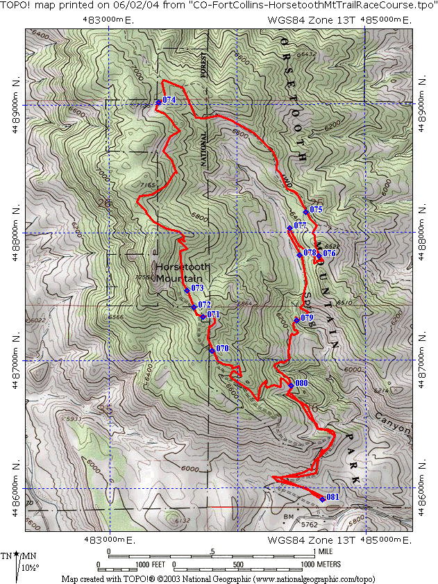
[ Map courtesy of Dan Turk ]
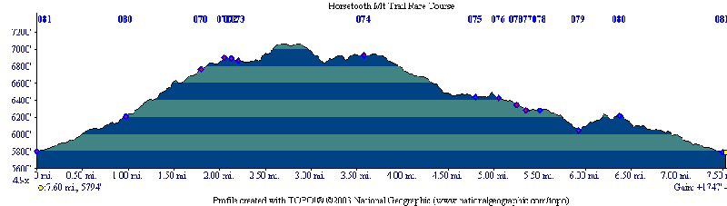
[ Elevation Profile courtesy of Dan Turk ]
For an official trail map from the park website, click here.
Any comments or questions? Send me an e-mail.
Home | About this Site | Disclaimer || Site Map | Subscribe to be notified when new content is posted to this site
|
Home | About this Site | Disclaimer || Site Map | Subscribe to be notified when new content is posted to this site
|