|
Clothes and Gear
 |
Sunglasses
|
|
Montrail Hiking Boots
|
|
2-tone hiking pants
|
|
thin, long sleeve (white) Patagonia Capilene top
|
|
thin, short sleeve (blue) Patagonia Capilene t-shirt
|
|
Marmot Precip jacket
|
|
North Face Cloud Hydration System
|
|
I used the jacket briefly at the top. I had
packed fleece glove liners, but forgot to put them in my pack. It was a bit
colder than I had expected, so in retrospect, a light fleece would have been
helpful. I sweat profusely on the way up, so I probably should have worn a hat
or headband, and taken a bandana to wipe my face with. Also, a lens cloth for my
glasses would have been very helpful. Some of my pictures were messed up because
sweat was on the camera lens. Also, the trail was quite snowy and icy after
leaving Fern Canyon, making for a treacherous ascent. I should have brought my
Leki Trekking Poles, but I think it also would have been useful to take
crampons, and maybe even an ice axe for that last stretch before the summit. But
we survived going up -- coming down that trail would have been more difficult.
Finally, the amount of water I took in my hydration pack (70 oz.) was
appropriate, since I still had some at the end of the hike. I had a couple
snacks, but didn't eat them until after the hike.

Mileage and statistics
0.6 miles NCAR parking lot to the Mesa Trail
0.4 miles Mesa Trail segment: NCAR trail to
South Boulder Creek Trail
0.3 miles Mesa Trail segment: South Boulder
Creek Trail to Bear Creek Canyon Trail
0.1 miles Mesa Trail segment: Bear Creek
Canyon Trail to Fern Canyon Trail
1.4 miles Fern Canyon Trail
1.8 miles Bear Peak West Ridge Trail
1.7 miles Bear Canyon Trail
0.3 miles Mesa Trail segment: Bear Creek
Canyon Trail to South Boulder Creek Trail
0.4 miles Mesa Trail segment: South Boulder
Creek Trail to NCAR Trail
0.6 miles NCAR Trail: Mesa Trail to NCAR
Parking Lot
In comparison, my Garmin eTrex Vista GPS
reported a distance of 8.46 miles. Part of the difference might be explained in
part by the difference in starting point and ending points, as we parked at
least a tenth of a mile from the trailhead. The Timex Bodylink Speed + Distance
System conked out before the end of the hike, but it was running more than half
a mile behind by about the 5 mile mark. I think it was having trouble keeping
the signal in Fern Canyon and in the trees going up the West Ridge.
Total Vertical Climb: 3276 feet
according to eTrex Vista GPS, 3000 feet according to Alta Sport Altimeter Watch
Moving time: 2h 36m
Stopped: 0h 44m
Moving average: 3.2 mph
Overall average: 2.5 mph
Performance
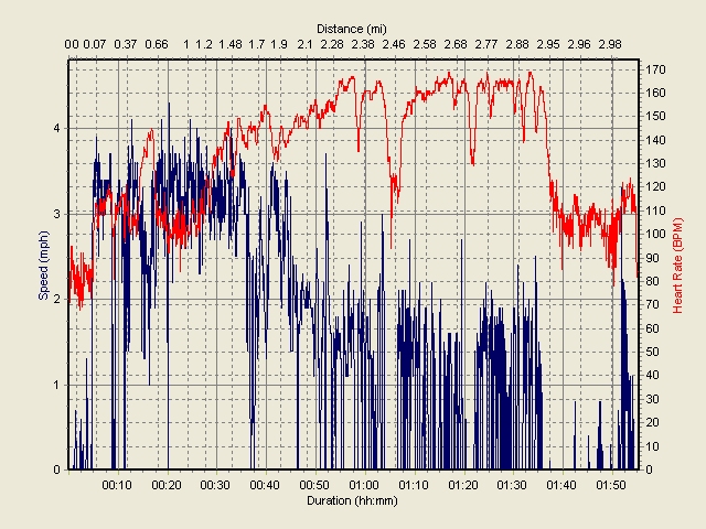
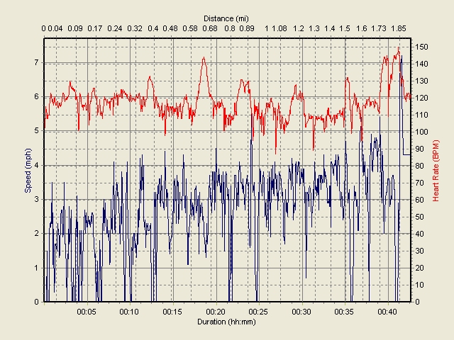
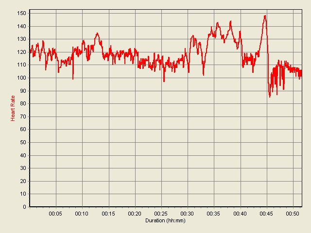
Here are graphs of my heart rate and speed during the
hike. About halfway down, the GPS shut down (low batteries?), so there is no
speed record for the last part. The first graph shows the portion of the hike
from the NCAR parking lot up to the summit and then the first part of the
descent. The second graph shows the rest of the descent, until the GPS shut
down. The third graph shows my heart rate for the remaining portion of the
descent.
|
Home
|
About this Site
|
Disclaimer
||
Site Map
|
Subscribe to be
notified when new content is posted to this site
|