|
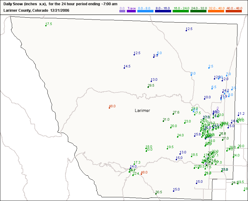
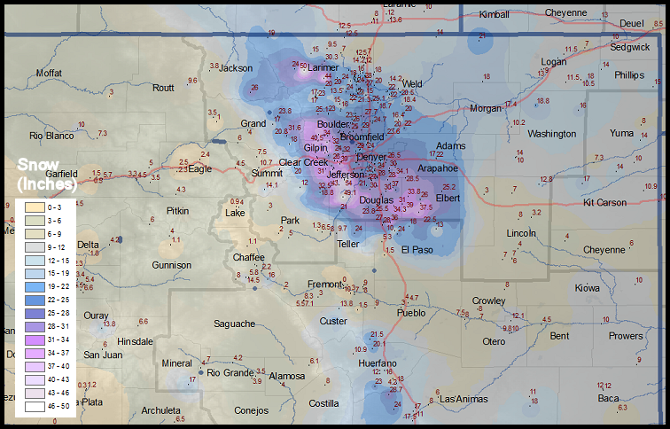
DECEMBER 20-21 NORTHEAST COLORADO SNOWSTORM
A strong winter storm system gained
momentum on December 20th, and it moved slowly along
the Colorado New Mexico border and then northeastward
across southeast Colorado and into Kansas. The storm
pulled moisture in from Texas and wrapped it in a
counter clockwise direction across northeast Colorado
and up against the Front Range creating favorable
upslope conditions. This type of system is the ideal
meteorological situation to allow for copious amounts of
snowfall for northeast Colorado. This storm was kind of
unique as the snowfall amounts was generally uniform
across the entire Front Range Urban Corridor. But as
usually occurs, as you increase in elevation up the
foothills, the snowfall increases. This was the case
again for this storm.
To view the an archived list of spotter reports,
click here.
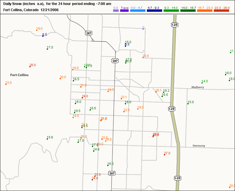
Zoomed map showing the Denver metro area:
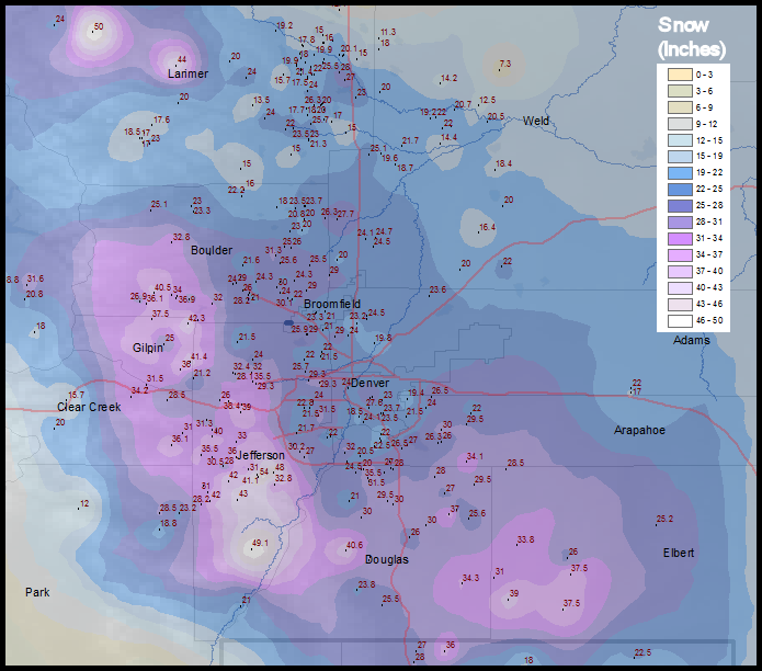
Also, we compiled a county by county list
of some of the heaviest snowfall amounts for each of the
counties that the National Weather Service Forecast
Office in Boulder is responsible for:
|
| Adams County Thornton
5 NNE
Thornton 2 N
Arapahoe County
Aurora 1 E
Littleton
Aurora 8 SE
Buckley AFB 10 SSE
Centennial 5 WSW
Boulder County
Jamestown 3 W
Nederland ESE
Niwot 2 SW
Boulder 7 SE
Broomfield County
Broomfield 1 NE
Broomfield
Superior 3 E
Clear Creek County
Idaho Springs 1 NE
Evergreen 8 NW
Georgetown 5 SSW
Denver County
Denver 2 ESE
Denver 14 S
Denver 8 SSW
Douglas County
Sedalia 7 SSW
Sedalia
Castle Rock
Franktown 8 S
Lone Tree 1 N
Elbert County
Kiowa 14 ENE
Elizabeth 6 SSW
Aurora 15 SE
Elbert 4 W
Gilpin County
Black Hawk 3 N
Black Hawk 8 N
Black Hawk 4 E
Grand County
Tabernash 3 ENE
Grandby 5 NNE
Winter Park
Williams Fork Dam
Jefferson County
Conifer
Boulder 11 SW
Evergreen
Golden 1 NW
Chatfield Dam 7 SW
Larimer County
Hourglass Reservoir
Glen Haven 7 N
Stove Prairie 3 SSE
Estes Park 11 SE
Fort Collins 5 SE
Loveland 7 W
Logan County
Sterling 15 SE
Crook
Park County
Bailey 4 NE
Phillips County
Holyoke
Summit County
Loveland Pass 2 S
Silverthorne 8 NNW
Dillon 1 E
Washington County
Fremont Butte 2 NNE
Yuma 10 NW
Weld County
Fort Lupton 6 WNW
Erie
Frederick
Greeley 3 ESE
Johnstown 1 WSW |
Inches
26.0
24.0
35.9
32.0
29.5
28.5
27.5
32.8
32.3
31.2
30.0
23.0
21.0
22.2
30.6
28.5
20.0
24.0
24.0
23.0
35.5
32.0
32.0
29.0
28.0
33.8
31.0
28.5
25.0
38.0
37.5
32.2
27.9
21.7
18.0
4.0
42.0
42.0
40.0
33.0
30.0
48.0
44.0
31.0
30.5
28.0
24.0
9.0
7.0
23.0
17.0
12.0
6.0
5.0
16.0
16.0
29.0
29.0
24.5
20.0
19.5 |
| The
weather spotter network really supported this office
with many critical snowfall reports during this unusual
winter storm. Unfortunately, we could not list them all
on this page. But we appreciate all your efforts for
taking and providing us with these observations! |
[Source: Denver National Weather Service
web page] |
[The following section has been archived from the Denver National
Weather Service web page]
The December 20-21
Winter Storm officially measured
20.7 inches
at the former Stapleton International Airport.
This puts this winter storm in 7th position in
strongest winter storms in Denver Weather History since 1946.
See the table below for the Top 12 Denver Snowstorms since 1946.
Denver’s Snowstorm Total
Snowfall Statistics
Greatest Amount Of Snowfall Over 5 Days: 45.7
inches intermittently from December 1-5, 1913
(37.6 inches of continuous snowfall (40
hours) recorded between December 4-5th)
The Top 12 Denver Snowstorms since 1946:
31.8 inches Mar 18, 2003
30.4 inches Nov 3, 1946
23.8 inches Dec 24, 1982
21.9 inches Oct 25, 1997
21.5 inches Nov 27, 1983
21.2 inches Nov 19, 1991
20.7 inches Dec 21, 2006
18.7 inches Mar 5, 1983
17.7 inches Nov 19, 1979
17.3 inches Apr 1, 1957
16.9 inches Mar 20, 1952
16.0 inches Oct 3, 1969
[Source: Denver National Weather Service web page]